
Disaster Impact Assessment and Detection, Greenfield Iowa
INTRODUCTION
Greenfield, Iowa, is a small urban area where aerial data can provide valuable insight into urban growth, infrastructure monitoring, and disaster impact assessment. This study uses high-resolution drone imagery acquired from OpenAerialMap to automatically detect built structures and vehicles using pretrained deep learning models.
PROBLEM STATEMENT
Manual mapping of urban features such as buildings and cars is time-consuming and inconsistent, particularly after natural disasters or rapid urban development. Greenfield, recently affected by a tornado, presents an urgent need for accurate, automated spatial assessments to support planning and recovery efforts.
OBJECTIVES
• Detect and map building footprints and vehicles using pretrained object detection models.
• Quantify detected features and assess their spatial distribution.
• Generate GIS-ready layers for local use in planning and emergency response.
STUDY AREA
Greenfield, Iowa, located in Adair County, is a small Midwestern town that was recently impacted by a tornado in 2023. This event created a pressing need for spatially precise damage and infrastructure assessments. The town’s urban morphology, composed of residential blocks, civic centers, and open spaces, presents an ideal case for drone-based object detection. High-resolution drone imagery from OpenAerialMap was used in this study to delineate building footprints and identify vehicle distributions across the town’s-built environment.
METHODOLOGY
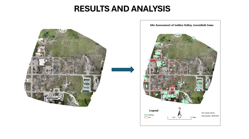
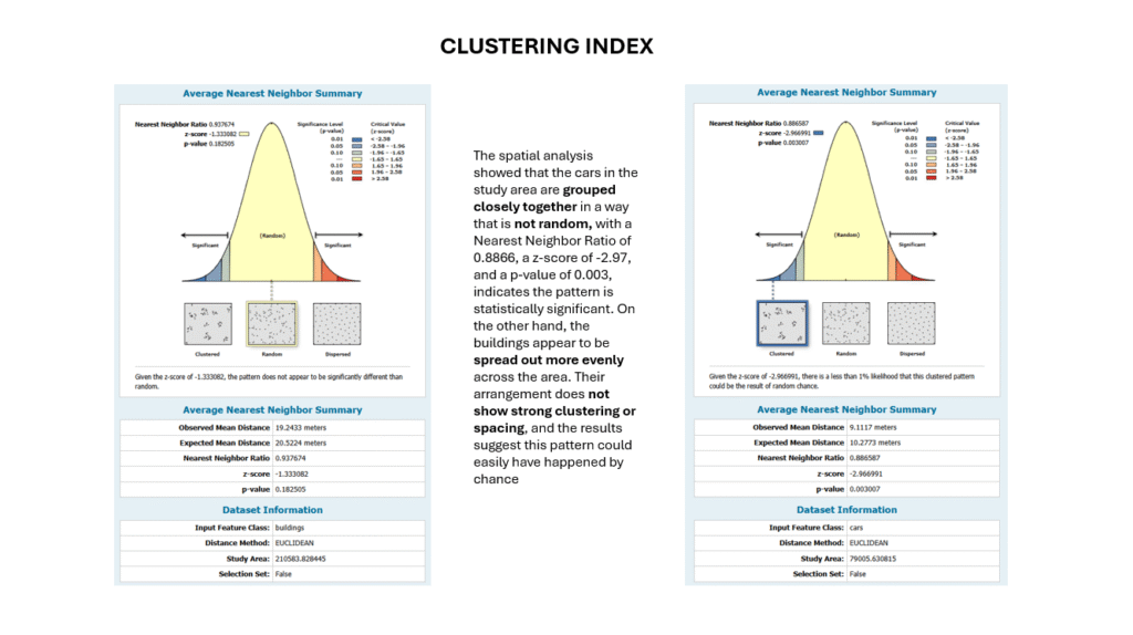
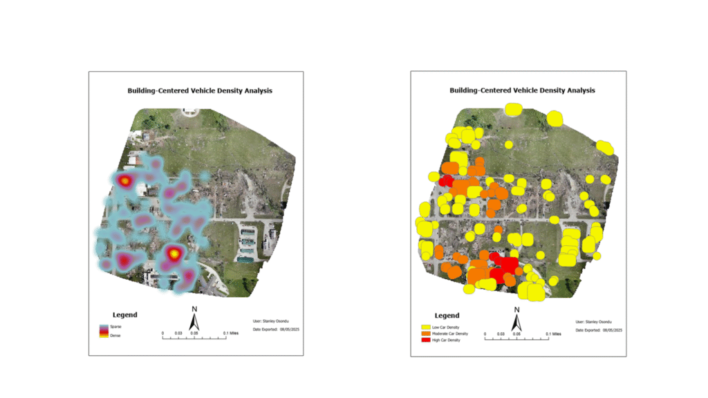
The study utilized RGB drone imagery from OpenAerialMap, processed using pretrained ArcGIS Pro deep learning models—for car detection and building extraction. The workflow involved preprocessing of drone imagery, applying object detection models, and generating geospatial vector outputs. These detections were then analyzed through proximity-based spatial analysis, particularly buffer analysis, which quantified the number of vehicles within a set distance from detected buildings. The results were visualized using graduated symbology and heatmaps in ArcGIS Pro, facilitating urban density interpretation and damage impact mapping.
RESULTS AND ANALYSIS
CHALLENGES
•Image resolution variation due to flight inconsistencies.
•Limited ground truth data for quantitative accuracy validation.
•Post-processing artifacts in edge buffers.
•Model limitations in project areas (e.g., cars detected as buildings).
CONCLUSION
The use of pretrained deep learning models on high-resolution drone imagery proved to be an effective approach for rapid object detection and spatial analysis in post-disaster urban environments. In Greenfield, Iowa, this method enabled efficient identification of building footprints and vehicles, with proximity analysis offering actionable insights into infrastructure accessibility and urban density. The study’s approach is replicable in similar small-town contexts and can be expanded through temporal change detection, damage severity classification, and integration with other disaster response datasets.
REFERENCES
Jozi, D., Shirzad-Ghaleroudkhani, N., Luhadia, G., Abtahi, S., & Gül, M. (2024). Rapid post-disaster assessment of residential buildings using Unmanned Aerial Vehicles. International Journal of Disaster Risk Reduction, 111, 104707. https://doi.org/10.1016/j.ijdrr.2024.104707
Cohen, M. C. L., de Souza, A. V., Liu, K.-B., & Yao, Q. (2023). A timely method for post-disaster assessment and coastal landscape survey using drone and satellite imagery. MethodsX, 10, 102065. https://doi.org/10.1016/j.mex.2023.102065
Gu, J., Xie, Z., Zhang, J., & He, X. (2024). Advances in Rapid Damage Identification Methods for Post-Disaster Regional Buildings Based on Remote Sensing Images: A Survey. Buildings, 14(4), 898. https://doi.org/10.3390/buildings14040898